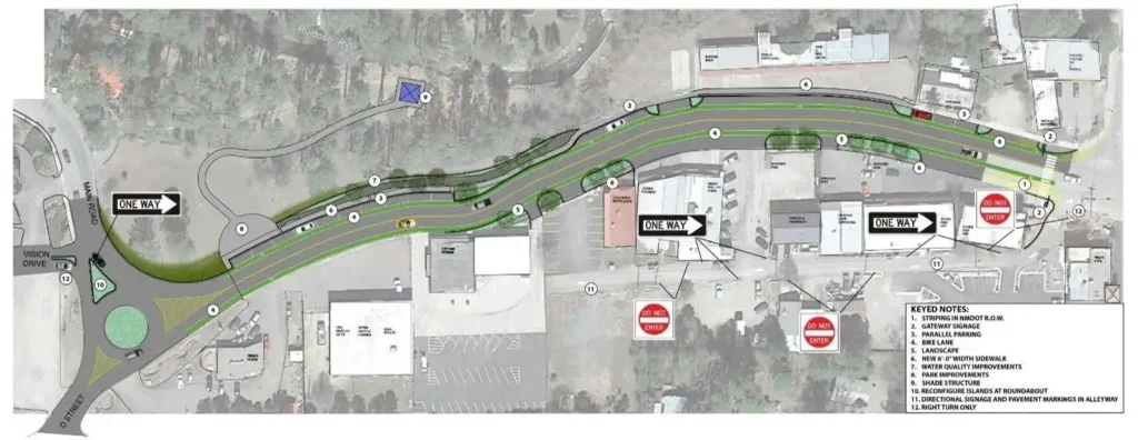
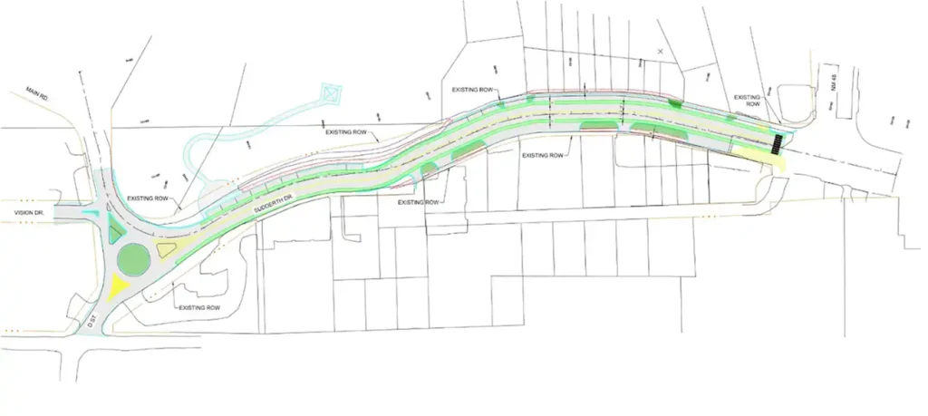
The current Upper Sudderth Revitalization Project is a continuation of the 2022 Historic Upper Canyon Gateway and Streetscape Improvements study, which proposed several alternative design concepts for street enhancements. As described below, these included Concept A and Concept B. The current Project has re-examined these concepts with input from the Study Team and Stakeholder Committee and expanded the range of alternatives to include Alternatives C, D, E, and F. The alternatives included different mixes of bicycle and pedestrian facilities, lane and intersection configurations, landscaping/streetscaping, parking, lighting, drainage features, signage, and other roadway enhancements. Six concepts (A-F) that combine specific design features are described below; most of these features can be mixed and matched to create a hybrid or preferred design concept.
To illustrate possible variations in design features, visual renderings have been developed and are included in the link below. In the renderings, Alternative 01 corresponds to Concept D on this page, Alternative 02 corresponds to Concept E, and Alternative 03 corresponds to Concept F. Please explore the different views by holding down the left button on your mouse and rotating the image and by watching the drive through videos. Click Here to view renderings of the alternative designs.
Preliminary Alternative – Concept A
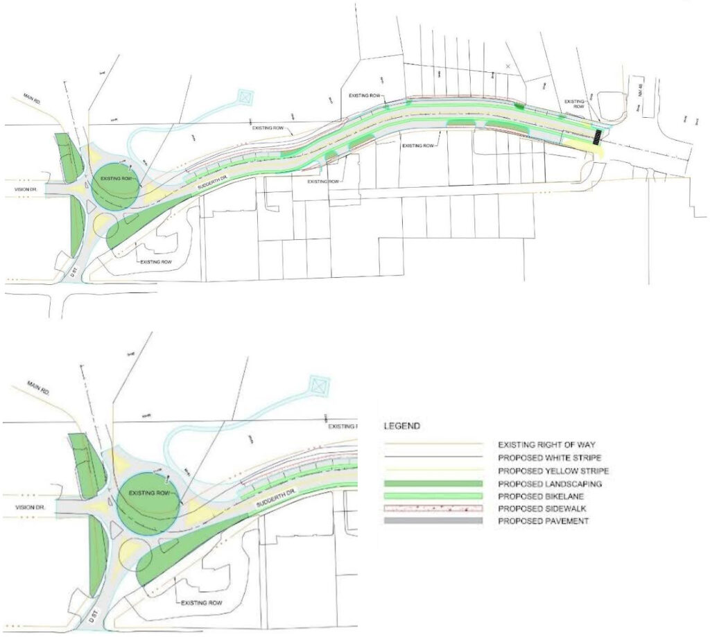
Concept A was developed during the 2022 Historic Upper Canyon Gateway and Streetscape Improvements study. It includes basic enhancements such as on-street bicycle lanes, 6-foot sidewalks, and parallel on-street parking. It would maintain the existing small diameter roundabout with improved lane channelization through pavement markings and raised islands. This alternative would not include crosswalks or sidewalks in the roundabout.
Concept A
Corridor
|
Roundabout
|
As shown in the Concept A property layout below, this alternative would not require additional right-of-way.
Property Layout – Concept A
Preliminary Alternative – Concept B
Concept B was also developed during the previous 2022 study and would include the same enhancements (bicycle lanes, sidewalks, and parallel parking) but it would provide a large diameter roundabout with pavement markings to designate the lanes. As shown below, the roundabout would not include sidewalk or crosswalks at the roundabout.

Concept B
Corridor
|
Roundabout
|
The property layout and inset below show that Concept B would require additional right-of-way. The right-of-way would be obtained from the Village-owned property just north of the roundabout and Sudderth.
Property Layout – Concept B
Typical Sections for Concepts A and B
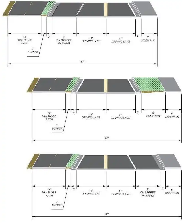
Except for the roundabout, the typical roadway sections for both Concepts A and B are the same. The sections vary through the Project corridor depending on the configuration of sidewalks, parking, and other features next to the driving lanes (see figure below). Both concepts provide one lane in each direction with bicycle lanes, curb and gutter, and sidewalks. Some areas include “bump outs” where the width of the sidewalk is widened. The bump outs may provide traffic calming and allow additional areas for the placement of signs or possible landscaping, street furniture, or other enhancements. On-street parking is shown in the typical sections where it is appropriate for the adjacent properties.
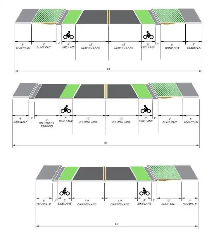
Typical Sections – Concept A and B
Preliminary Alternative – Concept C
Concept C is a new Project alternative that would include an eastbound bicycle lane and a 6-foot sidewalk on the south side, a 10-foot multi-use trail on the north side, flat angle on-street parking, and a mid-block pedestrian crossing. This alternative includes a large diameter roundabout with a concrete apron to accommodate large trucks, raised islands to channel traffic, sidewalks on the perimeter of the roundabout, and crosswalks at the streets entering the roundabout.
Concept C
Corridor
|
Roundabout
|
Concept C would have similar right-of-way requirements to Concept B due to the large roundabout diameter. The typical sections shown below would also vary depending on the configuration of parking and other features such as bump outs next to the driving lanes.
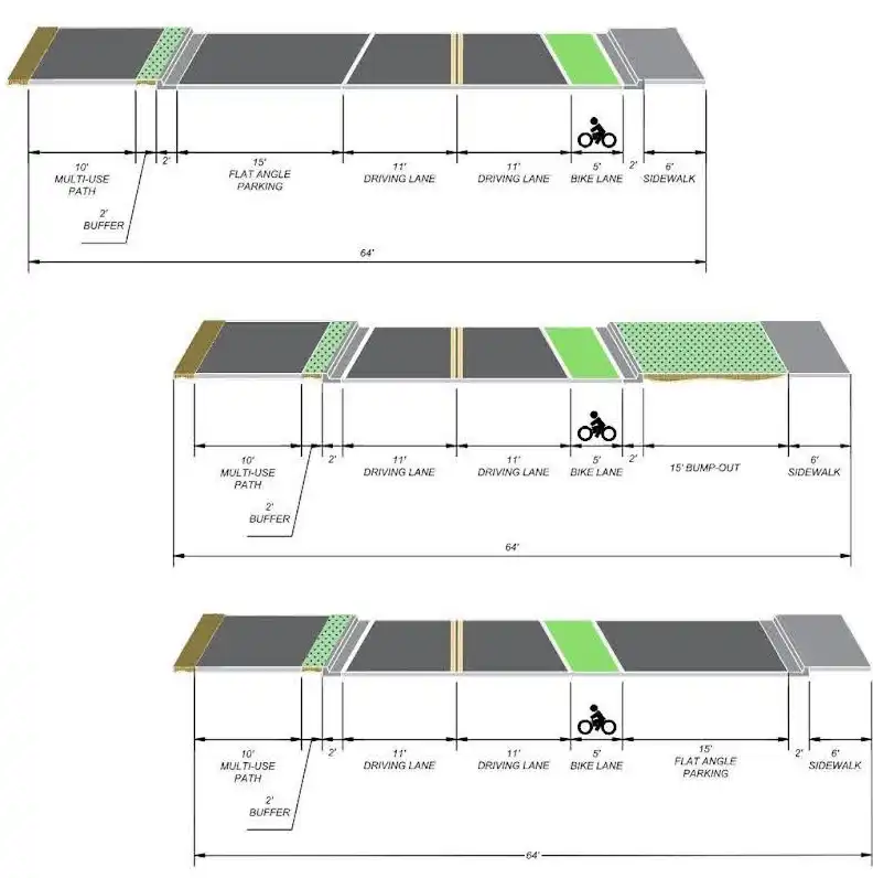
Typical Sections – Concept C
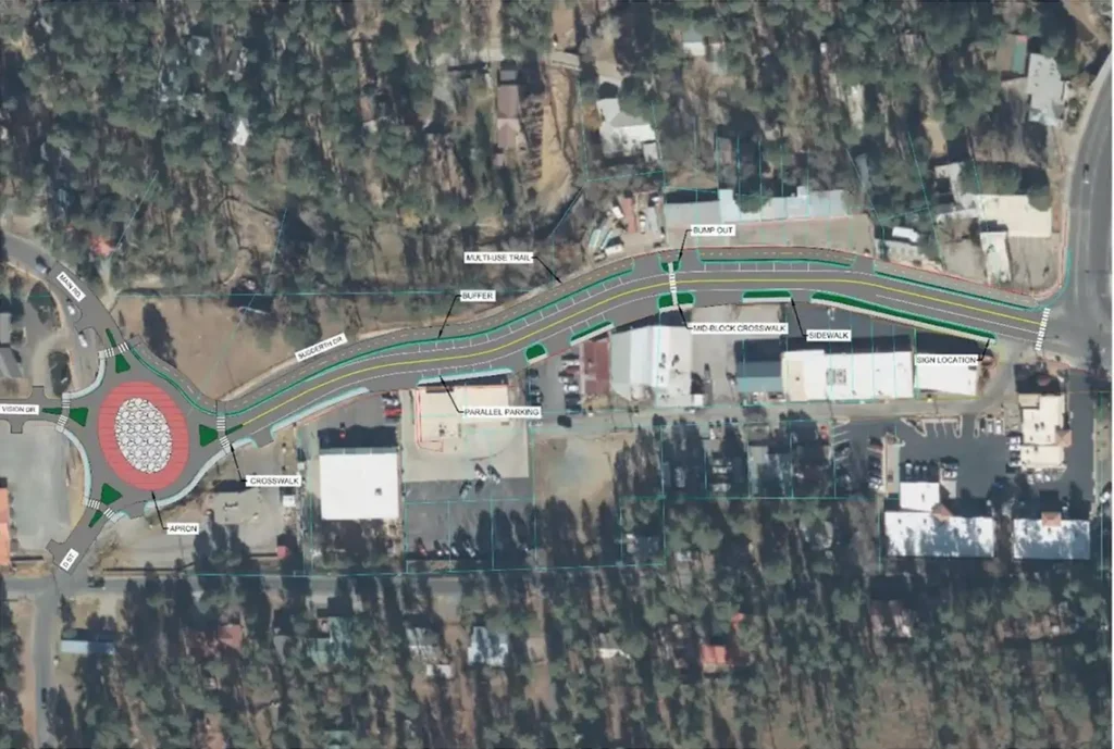
Preliminary Alternative – Concept D
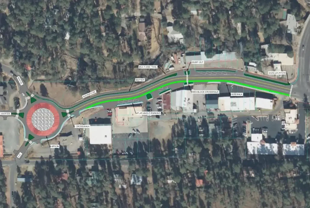
Concept D, also a new Project alternative, would include a 14-foot bi-directional muti-use trail on the north side, a 6-foot sidewalk on the south side, parallel on-street parking, and a mid-block pedestrian crossing. One of the reasons why on-street bicycle lanes were eliminated from this and other alternatives is that Ruidoso does not have bicycle lanes on other Village streets; thus, there would be no system continuity for bicycle lanes.
This alternative includes a large diameter roundabout with an oval shape that may fit better with the right-of-way and intersecting streets. An oval shape is an alternative with any large diameter roundabout concepts. The Concept D roundabout also has a concrete apron to accommodate large trucks, raised islands to channel traffic, sidewalks on the perimeter of the roundabout, and crosswalks at the streets entering the roundabout.
Concept D
Corridor
|
Roundabout
|
Concept D would have similar right-of-way requirements to the other large diameter roundabout concepts. The typical sections below would also vary depending on the configuration of parking and other features next to the driving lanes. The multi-use trail would be situated along the north side of the right-of-way.
Typical Sections – Concept D
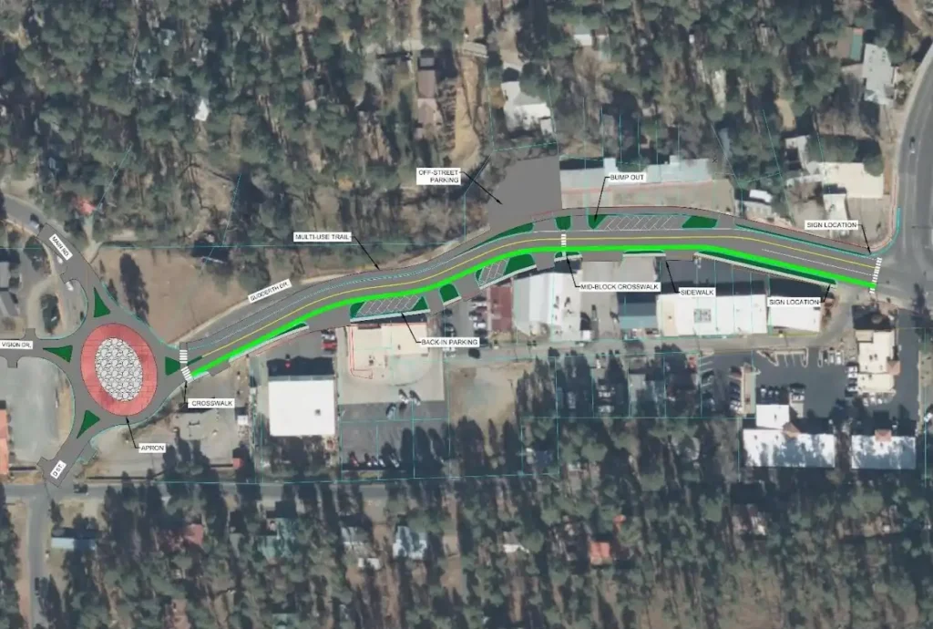
Preliminary Alternative – Concept E
Concept E is a new Project alternative that would include an eastbound bicycle lane and 5-foot sidewalk on the south side, a 10-foot muti-use trail on the north side, back-in on-street parking, a mid-block pedestrian crossing, and off-street parking. The back-in on-street parking is recommended by the Federal Highway Administration’s Manual on Uniform Traffic Control Devices for Streets and Highways to provide safer conditions where bicycle lanes and on-street parking exist together. This alternative also includes a large diameter oval roundabout with a concrete apron and raised islands. As shown, it does not include sidewalks or crosswalks around the perimeter of the roundabout.
Concept E
Corridor
|
Roundabout
|
The Concept E back-in on-street parking and typical sections are illustrated below.
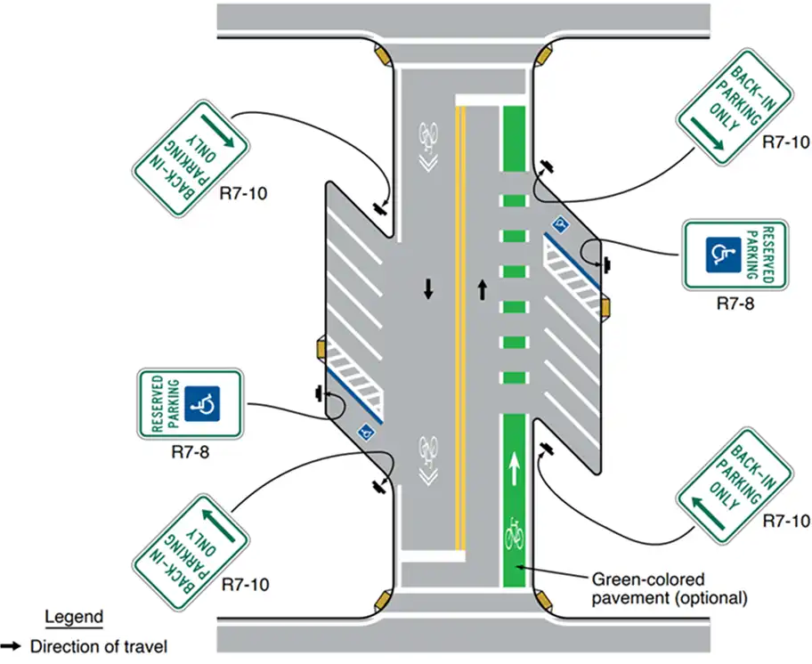
Back-in Parking – Concept E

Typical Sections – Concept E
Preliminary Alternative – Concept F
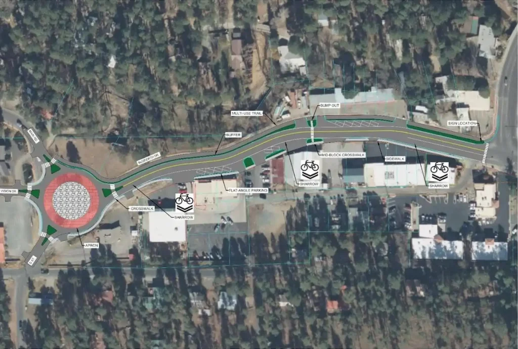
Concept F is a new alternative that would include an eastbound shared bicycle/motor vehicle lane (sharrow) and 6-foot sidewalk on the south side, a 10-foot muti-use trail on the north side, flat angle on-street parking, and a mid-block crossing. Sharrows are typically 14 feet wide or greater to accommodate both bicycles and motor vehicles side-by-side. The Concept F roundabout is shown as circular with an apron, raised islands, and sidewalk/ crosswalks around the perimeter.
Concept F
Corridor
|
Roundabout
|
Preliminary Alternative – Concept F-1
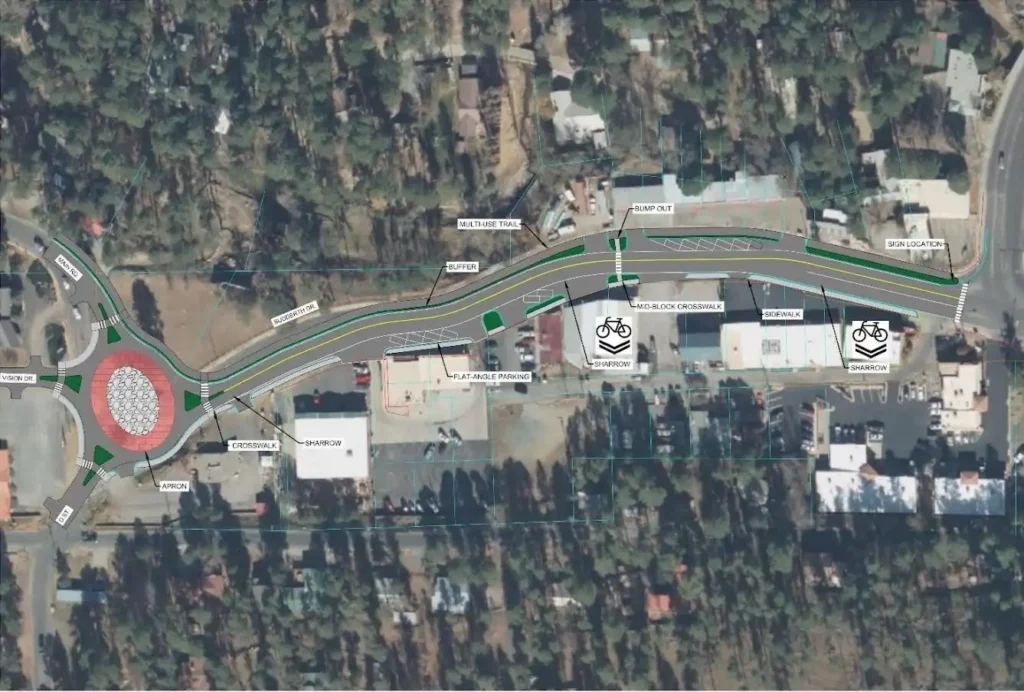
Concept F-1 illustrates the same features as Concept F with an oval roundabout.
Concept F-1
Corridor
|
Roundabout
|
The typical sections for Concepts F and F-1 are shown below.
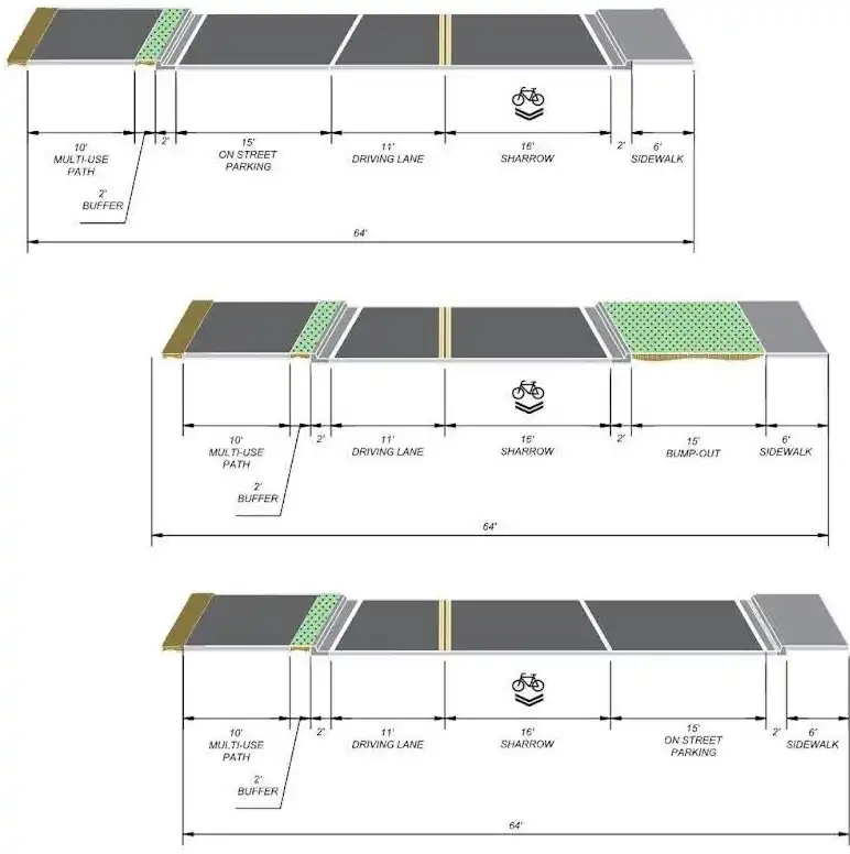
Typical Sections – Concept F and F-1
Preliminary Alternative – Concept G
Concept G is the result of input received at Stakeholder and Public Meetings. The majority of input and public preferred design features were discussed during a Public Meeting held on September 25, 2025. The comments requested that more pedestrian access be provided via an additional mid-block crosswalk and that on-street parking be maximized.
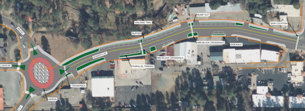
Concept-G
Corridor
|
Roundabout
|
The typical sections for Concepts G is shown below.
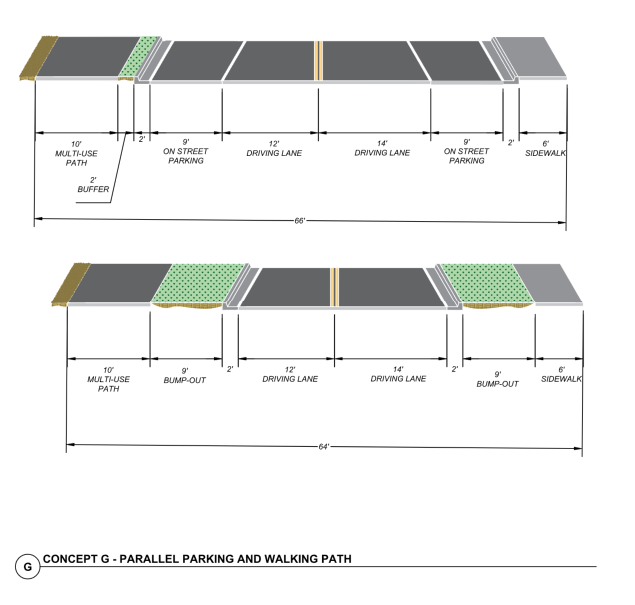
Typical Sections – Concept G
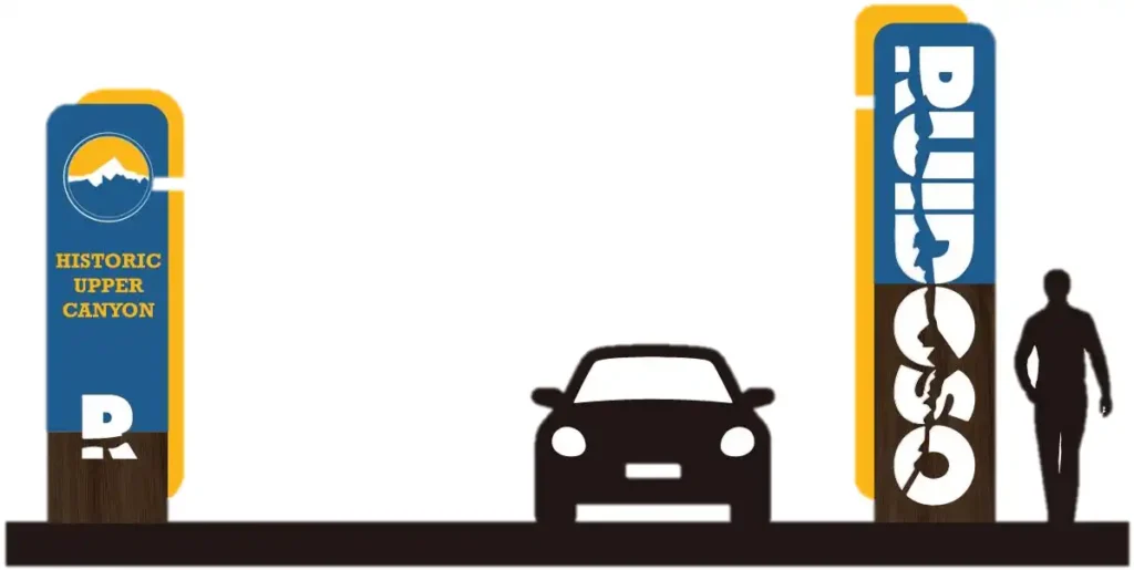
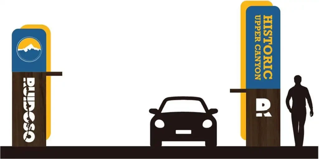
Gateway Signage Alternatives
An important part of the purpose of the Project is to enhance economic development along Upper Sudderth Drive. Gateway signage is a means to announce the presence of local businesses and attract visitors into the area. A number of preliminary signage concepts have been explored beginning in the 2022 study and continuing into the current Project. Several signage concepts are illustrated below. Sign dimensions and placement criteria are subject to traffic safety guidelines as well as local land use controls. The signage concepts will be developed further as the Project moves forward.